Wednesday, March 29, 2006

Top 10 WMS layers

Matt at PerryGeo lists his top 10 wms layers - it's an interesting list but I feel a little amerocentric but I haven't actually checked how many of them extend worldwide as my network is flaky today.

He makes a good point though that it is very hard to find good wms layers.

Friday, March 17, 2006

More on collaborative mapping

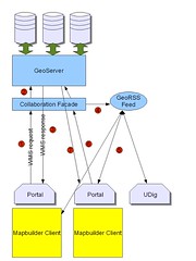
Previously I talked about how I would like to build a collaborative web portal system. Well during spring break I got some coding done and now things are starting to take shape. Here's a diagram of how it works (or should work).


Basically someone using the web portal (in yellow) has a mapbuilder client in one of the portlet windows which makes a wms request (1) to the collaboration facade, a simple servlet which passes the request on unaltered to GeoServer (2) (or which ever WMS you are using) while doing this it also extracts the bounding box of the request and the layers etc requested. This information it puts in a georss feed using a modified version of Informa that knows about geography (4). Meanwhile the WMS has returned a map to the client (3).

Another user of the portal polls the georss feed (5) and displays the bounding box in a small reference map so they can "see" where their colleges are looking at. If they are collaborating directly they second user can set their client to follow the leader (6,7) so that they are seeing exactly the map that she sees.

So far I've built the collaborative facade and I'm working on 1) making the boxes in the georss feed show up in mapbuilder and 2) thinking about how to do follow the leader in mapbuilder.

The first step has moved forward today as I've upgraded to firefox 1.5.1 and the mapbuilder head. I can see the demos of georss working now. So I think the next step is to work out how the shipping demo draws the tracks and look at drawing boxes somewhere similar and reading more complex georss documents.

Thursday, March 09, 2006

Guardian Bashes Ordinance Survey

There is a big debate going on over the freedom (as in beer) of public(ish) geodata in Great Britain started by the Guardian (a left wing newspaper). Obviously Ed Parsons has something to say in his completely not speaking for OS blog. GeoCarta: British Newspaper Bashes Ordinance Survey also has some discussion.

My take on the issue is that Crown copyright data should be freely available as generally speaking the public taxes have paid for it so they should see the benefits. Ed of course argues that taxes don't fund OS any more, which is true if off the point. What he conveniently forgets that until recently the OS was wholly funded by tax payers. So the majority of features on OS maps were mapped by a tax funded body - has your house changed much since 2000? OK so there are new areas of building and new roads and such like to be added but that's really not that much in the overall scheme of things. It should also be noted that for the wild and inaccessible parts of the country the government already pays OS to map these areas, sort of a mapper of last resort since no one else would map them but they are needed for emergency planning etc.

So the question is would it kill the OS to free its data? I guess that depends on how they do it. Obviously if they have to continue to make a "profit" for the treasury then they would be in trouble, though I'd guess that people would still buy the printed OS maps. However if we got smart and reckoned in the cost to other government (national and local) and public-sector agencies (universities, hospitals etc) as a cost against OS we could afford to fund the civil servants like Ed directly from taxes and still show a profit. Then money OS could make from consulting, selling paper maps etc would be profit too.

Disclaimer: I like Ed - he bought me a drink once, my wife used to work for the government (so I know about the idiocy that goes on) and I have moved to the US so it won't be my taxes that pay for this!
Thursday, March 02, 2006

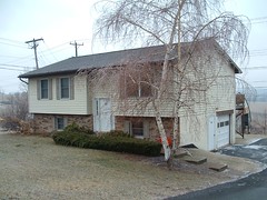
Our new House


Our House
Originally uploaded by ianturton.
A picture of our new house on the edge of State College. Geotagged to within a picodegree of it's life in case you ever want to visit.

Wednesday, March 01, 2006

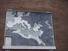
Roman Empire Map


Roman Empire Map
Originally uploaded by ianturton.
Mostly just a test to see if I can blog from Flickr. But its a nice map too.

A nice google earth demo

Today I spent entirely too long playing with Google Earth and aprskml. This is a server writen in Java that connects to an internet source of APRS packets and converts them into KML. You can then connect Google Earth to the server and watch things move about, or if you pick a house sit still!

APRS is a real-time tactical digital communicatons protocol for exchanging information between a large number of stations covering a large (local) area. As a multi-user data network, it is quite different from conventional packet radio. The best bit is that the packets can be picked up and forwarded over the internet for people to view, map and otherwise play with. For example I spent this afternoon watching a tourist light airplane trip over the Florida Keys.

I'm looking at making use of APRSKML as a basis for a GeoRSS server that will allow me to watch planes etc through the geotools GeoRSS datastore that I haven't got round to writing yet because watching things move is so adictive.