More on collaborative mapping
Previously I talked about how I would like to build a collaborative web portal system. Well during spring break I got some coding done and now things are starting to take shape. Here's a diagram of how it works (or should work).
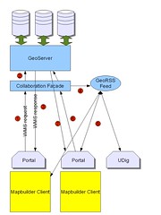
Basically someone using the web portal (in yellow) has a mapbuilder client in one of the portlet windows which makes a wms request (1) to the collaboration facade, a simple servlet which passes the request on unaltered to GeoServer (2) (or which ever WMS you are using) while doing this it also extracts the bounding box of the request and the layers etc requested. This information it puts in a georss feed using a modified version of Informa that knows about geography (4). Meanwhile the WMS has returned a map to the client (3).
Another user of the portal polls the georss feed (5) and displays the bounding box in a small reference map so they can "see" where their colleges are looking at. If they are collaborating directly they second user can set their client to follow the leader (6,7) so that they are seeing exactly the map that she sees.
So far I've built the collaborative facade and I'm working on 1) making the boxes in the georss feed show up in mapbuilder and 2) thinking about how to do follow the leader in mapbuilder.
The first step has moved forward today as I've upgraded to firefox 1.5.1 and the mapbuilder head. I can see the demos of georss working now. So I think the next step is to work out how the shipping demo draws the tracks and look at drawing boxes somewhere similar and reading more complex georss documents.
posted by Ian Turton at 11:33 AM
![]()
![]()

0 Comments:
Post a Comment
<< Home